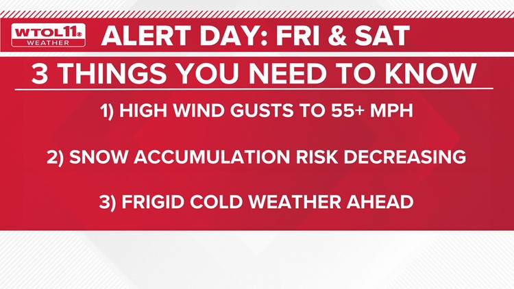
TOLEDO, Ohio — WTOL 11's weather team has called for an ALERT DAY for a significant storm of impact possible Friday through Saturday. While snow potential has decreased, the wind potential has increased. Here is what is new:
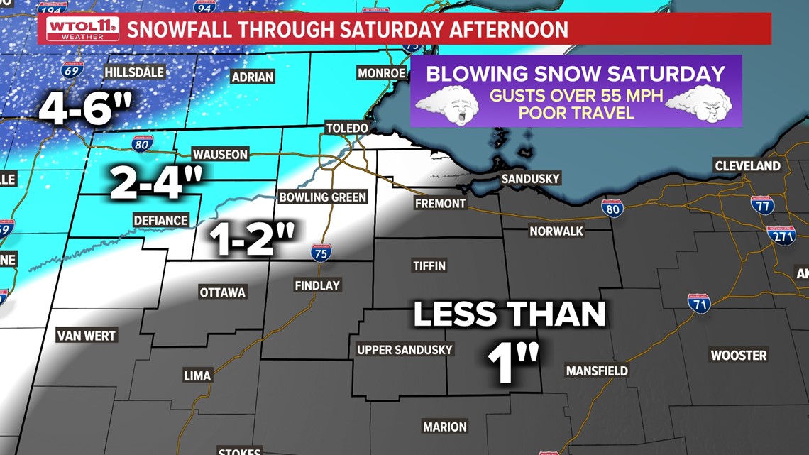
Decreasing Risk of heavier snow. The greatest accumulation will be more than 2 inches northwest of Toledo.
Increasing Risk of high wind gusts. Expect gusts over 55 mph.
Increasing Risk of major cold arriving Sunday and lasting through next week.
Wind and cold remain the greatest impacts of this system. It is possible wind damage and scattered power outages will be possible if winds of 55 mph or greater materialize. Power outage concerns would be amplified by the bitter cold arriving into the weekend.

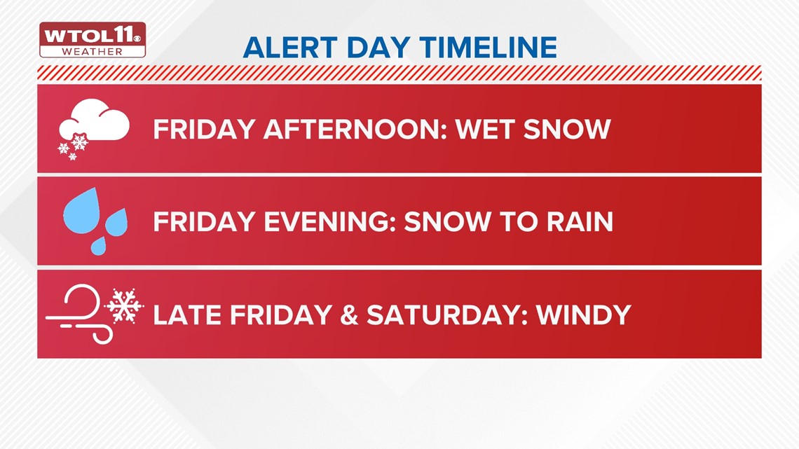
Friday night:
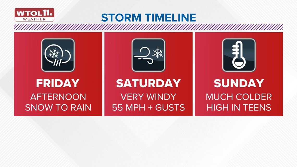
Though some snow may accumulate, snow will transition to wintry mix to rain late Friday afternoon and evening.
Overall, lower snow totals may result from this storm, but certain impacts from high winds and extreme cold are expected.


RELATED: ALERT DAYS in effect Friday, Saturday for extreme cold; high wind warning issued | WTOL 11 Weather
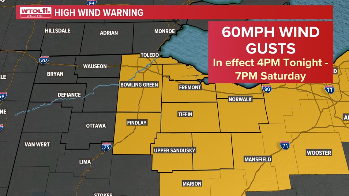
A high wind warning has been issued by the National Weather Service ahead of expected wind gusts near 60 mph. The warning is in effect Friday at 4 p.m. and is expected to last until Saturday at 7 p.m.
The following map shows which counties are under high wind warnings in northwest Ohio and beyond:

Saturday:
Expect dramatically colder temperatures Saturday accompanied by windy conditions and continued snow.
Blowing snow and hazardous travel will be possible. Significant snow has shifted and become more likely northwest of Toledo where totals in excess of 4 inches will be possible. Lower totals to minimal accumulations for the Toledo metro to the south and east.
This shift means that the risk of high winds has increased. Gusts of 50-55 mph may be frequent Saturday.

Sunday:
Temperatures will drop to bitterly cold on Sunday. Expect temperatures to stay extremely cold into early next week with highs in the teens and overnight lows in the single digits to near zero.
Bitter and dangerous cold conditions will continue next week and will remain a significant concern with highs in the teens and lows near or below zero. Wind chills may reach -20 to -25 for several days next week.


More on WTOL:
➡️ Download the WTOL 11 news app for Apple here or get it in the Google store here.
➡️ Get a fresh start to your morning and wrap up your day with the latest news and your WTOL 11 Weather forecast delivered right to your inbox!
WTOL 11's Your Morning Blast and Your Evening Blast deliver stories from northwest Ohio, southeast Michigan and beyond to keep you informed. Click here to get on the list!
➡️ Looking for the lowest current local gas prices? Check out the WTOL 11 gas price tracker, powered by Gas Buddy, here.
➡️ Stay up to date on what's happening in your community with a 24/7 live stream and on-demand content from WTOL 11+. Our free WTOL 11+ apps are available on Roku and Fire TV.
WTOL 11+ features the latest breaking news and weather, plus daily talk shows, coverage of your favorite sports teams from Locked On, fact-checking from VERIFY and the latest trending stories from Daily Blast Live.