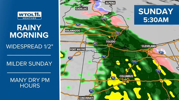
WTOL Forecast
Weather News
- National Weather Service confirms Saturday tornado in Portage County
- PHOTOS: Northwest Ohio experiences dazzling display of Northern Lights
- Solar storm hits Earth, producing colorful light shows across Northern Hemisphere
- Northern lights could be visible in Ohio overnight during strong to severe geomagnetic storm
10-Day Forecast
Tue
May 14
72
53
40%
9
MPH
SE
Chance of showers. Highs in the low 70s and lows in the mid 50s.
62%
Moderate
6:14 AM
8:46 PM
Wed
May 15
71
49
0%
11
MPH
SSE
Showers ending by midday. Highs in the low 70s and lows in the mid 50s.
72%
Moderate
6:13 AM
8:47 PM
Thu
May 16
78
55
0%
11
MPH
SW
Times of sun and clouds. Highs in the mid 70s and lows in the low 60s.
66%
Very High
6:12 AM
8:48 PM
Fri
May 17
73
56
40%
13
MPH
SSW
Rain with a few rumbles of thunder. Highs in the low 70s and lows in the upper 50s.
61%
Moderate
6:12 AM
8:49 PM
Sat
May 18
77
58
20%
12
MPH
SSW
Plenty of sun. Highs in the upper 70s and lows in the low 60s.
58%
Very High
6:11 AM
8:50 PM
Sun
May 19
81
58
10%
11
MPH
NW
A few clouds. Highs in the low 80s and lows in the low 60s.
58%
Very High
6:10 AM
8:51 PM
Mon
May 20
84
55
20%
12
MPH
WNW
Partly cloudy, chance of a thunderstorm. Highs in the upper 70s and lows in the upper 50s.
60%
High
6:09 AM
8:52 PM
Tue
May 21
81
56
30%
12
MPH
WNW
Partly cloudy. Highs in the low 70s and lows in the upper 50s.
57%
Very High
6:08 AM
8:53 PM
Wed
May 22
78
55
40%
12
MPH
NW
Showers possible in the afternoon. Highs in the upper 60s and lows in the mid 50s.
62%
High
6:07 AM
8:54 PM
Hourly Forecast
4 PM
Mon
82°
20%
12
MPH
SW
5 PM
Mon
81°
20%
13
MPH
SW
6 PM
Mon
79°
20%
11
MPH
SSW
7 PM
Mon
78°
20%
9
MPH
SSW
8 PM
Mon
76°
20%
7
MPH
SSW
9 PM
Mon
73°
10%
5
MPH
SSW
10 PM
Mon
71°
20%
4
MPH
S
11 PM
Mon
69°
20%
4
MPH
S
12 AM
Tue
68°
20%
5
MPH
S
1 AM
Tue
67°
20%
5
MPH
S
2 AM
Tue
66°
40%
5
MPH
S
3 AM
Tue
65°
50%
5
MPH
SSW