

TOLEDO, Ohio — With Christmas just a few days away, you may be wondering if you'll wake up to a blanket of snow to ring in the holiday. Christmas snow typically only occurs one third of the time and is far from a guarantee in the Midwest. So what are our white Christmas chances this year? Meteorologist John Burchfield answers that question in this week's edition of Climate Friday.
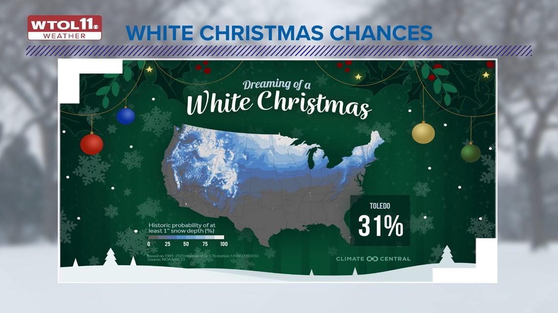
While Christmas movies typically portray the holiday with gentle snowfall, this depiction isn't always accurate. Only 31% of Christmases, just shy of one in three, brings snowfall in Toledo. One inch of snow depth is the minimum requirement to meet the definition of a white Christmas.
When was the last time we saw an inch of Christmas snow? In 2020, exactly 1.0 inch of snowfall dusted the ground, making for a beautiful holiday landscape. 2020 stands out from other Christmases in recent memory, and more often than not, snow-lovers have woken up to bare grass.
Christmas 2022 brought just a trace of snowfall. In 2021, we saw none. Christmas 2019 and 2018 also remained snow-free. While 2020 brought that much-desired Christmas snow, many years in recent history have not delivered holiday snowfall. The last time we saw over an inch of Christmas snow was 2005, which brought 1.1 inches of accumulation.


While recent Christmases have been relatively sparse in the snowfall department, what do the record books tell us about Christmas snow?
Snow-lovers, this list is for you. Our all-time snowiest Christmases on record occurred primarily during the first half of the 20th century. Topping the list is the Christmas of 1909 which brought a whopping 10.8 inches of snowfall. Coming in second is 1951, which delivered 9.6 inches of Christmas snow. Christmas, 1915 came with exactly half a foot of snowfall. In 1944, Santa delivered 5.5 inches of snowfall. Finally, 1935 featured 4.1 inches of accumulation.


While these white Christmases stand out in the record books, significant snowstorms on Dec. 25 are hard to come by. Christmas Day snowfall records date back to 1891 in the Toledo area, providing a snapshot into historical Christmas snow. Over the years, 54 Christmases have delivered zero snowfall and another 30 have brought just a trace of accumulation.


This historical data shows the rarity of measurable Christmas snow. 20 Christmases have brought between one and four tenths of an inch of snow. Nine Christmases have brought between half an inch and nine tenths of an inch.
While these dustings may satisfy some snow-lovers, this range of snowfall under an inch does not meet the official definition of a white Christmas. After all, a dusting of snow isn't even enough to cover the grass, let along build a snowman. Just seven years have brought between one to three inches and six have dished out over three inchers of snow.
While measurable snow occurs about one in three years, a white Christmas of an inch or more is even rarer. Most Christmases over the years have come without snow or just barely a dusting, and significant winter storms have been few and far between.

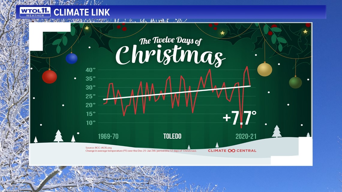
In general, Christmas weather is growing milder and less snowy. Climate change is rendering Christmas snow harder to come by. While global warming is impacting the entire calendar year, December has felt the brunt of the impacts, warming by more than any other month.
In the past decade alone, December temperatures have risen 3.1 degrees, leading to more Christmas rainfall than snow with milder temperatures. Even in today's era of climate change, Christmas temperatures are often erratic due to variations in the jet stream and weather pattern. Last Christmas was cold with a high temperature of 15 degrees. Wind chills ushered in bitterly cold Christmas conditions.

2021 was the polar (pun intended) opposite, featuring balmy conditions with a high temperature of 58 degrees. In addition to bringing an inch of fresh snowfall, Christmas 2020 was cold with a high temperature of 24. Dec.25, 2019 was another warm one with a high temperature of 58. Lastly, Christmas, 2018 featured a seasonable high temperature of 39. The WTOL 11 weather team is forecasting a milder Christmas this year as the warm and dry weather pattern persists into the latter half of December.
RELATED: Is our winter season shrinking?
Despite the ups and downs in Christmas temperatures, the data shows that Christmas snow is clearly trending down. Even in today's era of climate change, we will inevitably still experience white Christmases and cold temperatures. Both are unlikely this year, and you can trust the WTOL 11 weather team with the latest holiday forecast.
MORE FROM CLIMATE FRIDAY ON WTOL 11