
TOLEDO, Ohio — After several weeks of cold and snowy weather, late January has brought the return of mild and rainy conditions. Now that winter is almost two-thirds complete, you may be wondering where we stand in terms of snowfall and temperatures.
In this final Climate Friday edition at the end of January, Meteorologist John Burchfield breaks down the numbers and previews what you can expect as we round the corner into February.
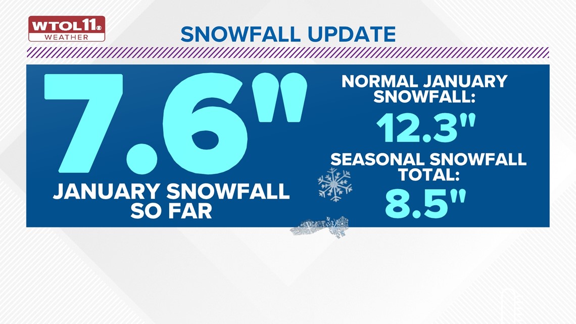
With just 8.5 inches of snow, this season has brought barely any meaningful accumulations. Seasonal snowfall in the Toledo area is less than half of what's normal. After a historically mild and dry December, January has brought the return of cold and snowy conditions. With 7.6 inches of snowfall, this month has gradually eroded the snowfall deficit.


Even with a more active winter weather pattern, however, this month has still failed to deliver any heavier accumulations that many people associate with the month of January. So far this month, we are below average in the snowfall department.
January is statistically the snowiest month of the year with a typical snowfall total of 12.3 inches. We will likely fall well below this normal foot of snow, and the WTOL 11 10-day forecast features very little if any accumulating snow through the end of the month.

How does this January stack up compared to last year? Last January only brought 6.8 inches of snowfall through today's date, Jan. 26. The entire month only delivered 7.9 inches of accumulation, just 64% of our typical monthly average of 12.3 inches.
This January will likely end with similar snowfall amounts to 2023. How will you remember this January weather-wise? Despite the recent stretch of wintry weather, this month will go down in the record books as one with a relatively small amount of snow.


Snowfall has been hard to come by not just in Toledo, but across much of the region. The entire Buckeye State is below average in the snowfall department this month. Compared to Toledo's 7.6 inches of accumulation, Cleveland has picked up 9.5 inches; Columbus, 5.0 inches; Cincinnati, 4.6 inches; Mansfield, 4.6 inches; Akron, 7.5 inches.

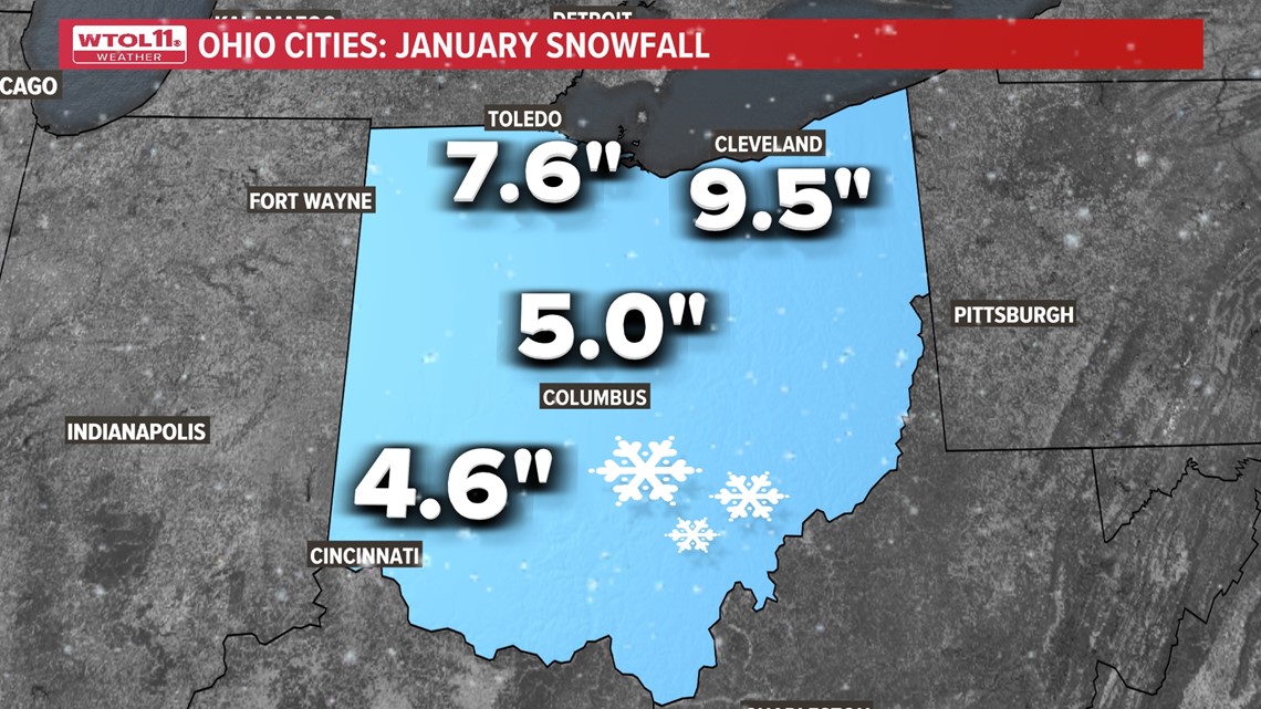
Each one of these cities is well below average compared to a typical January. Most notably, Mansfield is over half a foot below average and Cleveland is 4.8 inches shy of normal. This weather pattern has brought a relatively mild winter with little snowfall for much of the region.
So how has January fared in terms of temperatures? After a mild start to the month followed by a frigid mid-January, this month is slightly below average in terms of temperatures. As of Wednesday, Jan. 24, the month as a whole was only 1.5 degrees colder than average.

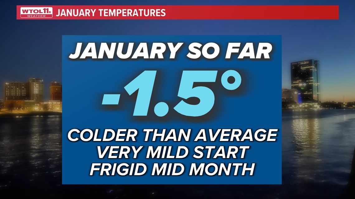
This was largely shaped by a cold snap during the third week of the month. Jan. 14 brought an overnight low temperature of zero degrees. The following day, temperatures plunged to -2 degrees. Jan. 16 and 17 each brought low temperatures of 4 degrees.
This week of cold weather has skewed the overall mean January temperature toward the colder side of the spectrum, but the milder final days of the month will likely tip the scale back toward more normal readings. In all likelihood, January will go down as a month with near normal temperatures, which doesn't tell the full story, as this month has been a roller coaster with many ups and downs.
RELATED: Climate Friday | From frigid temperatures to snowfall records: Winter weather across the country
After our recent brush with winter, the weather pattern will turn much milder and drier into the start of February. The 10-day forecast features many dry days with highs in the 40s, and even a few temperatures closer to 50 degrees.
This change in the weather signals a shift toward the more characteristic El Niño conditions we experienced in December. Because equatorial Pacific Ocean waters remain very mild, the jet stream will likely remain active in the southwestern United States, delivering frequent doses of steady rain, and quiet across the Midwest, keeping weather mild and dry across the Great Lakes Region.

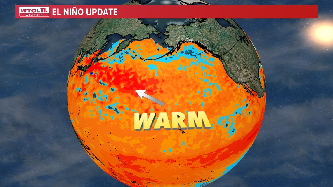
Early February will bring a typical El Niño weather pattern with relatively mild and dry conditions. Stay tuned to the WTOL 11 10-day forecast as we round the corner into the third month of winter and subscribe to the Climate Friday Newsletter for new information every week.
WATCH MORE FROM WTOL 11 WEATHER