
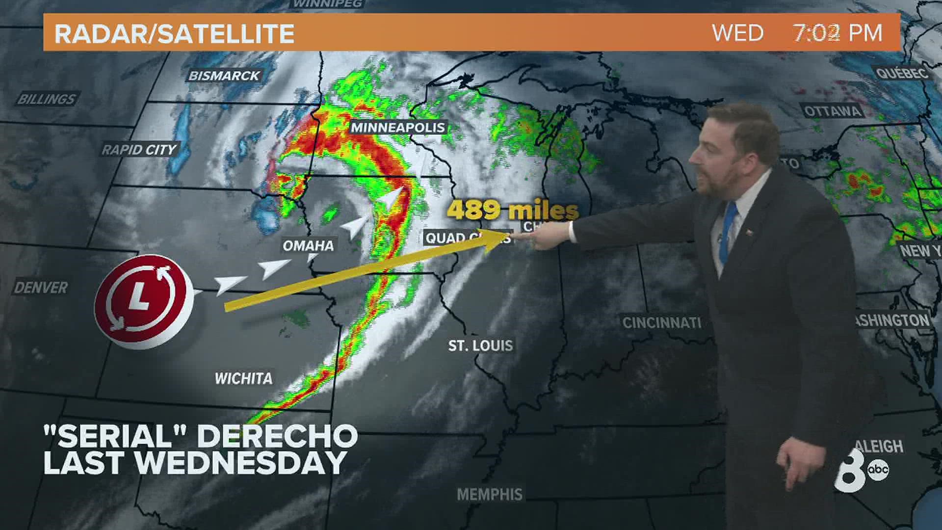
MOLINE, Ill. — Did you have "December Derecho" on your 2021 bingo card? If so, you scored big with a never-before-seen event for this time of year that rolled through the Midwest and Quad Cities on Wednesday, Dec. 15.
The phenomenon, known as a "serial derecho" featured a line of intense thunderstorms that brought winds in excess of 80 mph to much of the region.
According to the Storm Prediction Center and National Weather Service, this is the first known derecho that occurred in the month of December, not only for the Quad Cities but also for the entire U.S.
What made this derecho different from the one that rolled through in August of 2020? It's all about the timing on two fronts. One features the synoptic setup that involves the position of fronts, low-pressure systems, and the position of the jet stream. The other deals with the amount of foliage on the trees.
The derecho of 2020 that arrived on Aug. 10 was a "progressive" derecho and had a different environment to work with. First, this event unfolded during the warmer summer months when storm energy is plentiful, almost off the charts at times. Storms formed along a stationary front that featured a highly unstable air mass in its vicinity. Second, trees remain full of leaves giving wind more surface area to grab onto.


The derecho of 2021 that moved through recently had different dynamics to work with, forming along a powerful cold front that was attached to an equally powerful area of low pressure. A very strong jet stream also helped push significant winds beneath the storms as they raced across the Midwest.
The other difference? Most if not all of the leaves on our trees had already fallen. That means less surface area for winds to grab hold of and less opportunity for widespread tree and other damage.

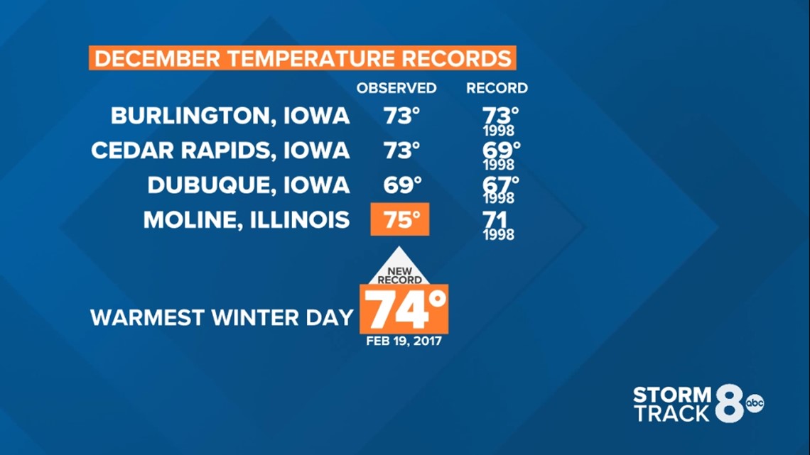
Derecho forecasting continues to be a very complex process, rarely predicted more than just hours in advance as opposed to days. Certainly, we had a remarkable amount of warmth in the region to support such a strong storm system. Several records were broken on Dec. 15, including the warmest observed December temperature in the Quad Cities AND warmest winter day.
Those were not the only records broken, though. This was the first derecho known to have formed during the month of December in the U.S. According to the Storm Prediction Center, the event also set a record for the most number of hurricane-force (75+ mph) thunderstorm wind gusts in a day (62 total) since 2004. The previous record was from the August 10, 2020, derecho with 53 reports.
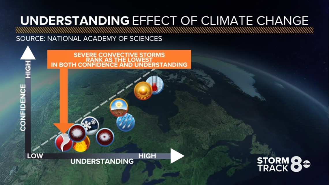
Is there a climate change role here?
The scientific community continues to investigate specific events looking for clues and possible links to climate change. Overall, our confidence and understanding of how climate change impacts events like derechos are quite low.
As we previously reported, scientists have discovered that there is a possible role when it comes to climate change and the eastward shift of damaging storm systems.

When assessing the impact of climate change, it's important to remember that you can't exactly pinpoint one particular event, rather you have to look at the bigger picture. Is the intensity of these events increasing? Are they becoming more frequent? Those are the questions scientists will be answering in the years to come.