
TOLEDO, Ohio — February is in the rearview mirror and March is upon us. The month of March kicks off meteorological spring, and turning over the calendars marks the start of a new season.
This winter barely brought any snowfall or bitterly cold temperatures - a sign of the new climate normal. While climate change played a role in this winter's weather, so did the weather pattern across the region.
To start off, let's explain meteorological seasons and how they differ from what you may think of as the start of spring. Meteorologists divvy up seasons into three-month chunks for record-keeping purposes.

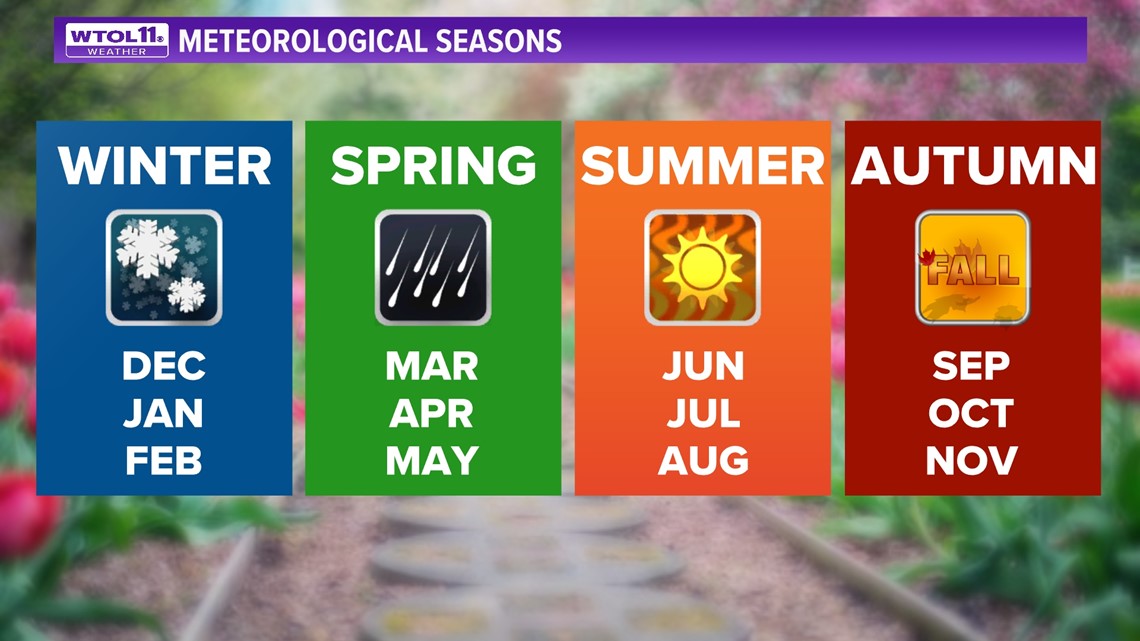
Meteorological winter spans from December to February. Spring includes March through May. Summer encapsulates June though August. Autumn stretches from September through November.
Astronomical seasons differ and depend on the date of spring and fall equinox and summer and winter solstice. The exact date of the start of astronomical seasons changes from year-to-year, whereas meteorological seasons remain set in stone. This makes record-keeping and data collection more simple and consistent.
While March 1 marks the start of the spring season to meteorologists, astronomical spring doesn't begin for another 17 days.
So how did the winter of 2022-2023 stack up by the numbers? In terms of temperatures, this winter season went down as an exceptionally mild one. December kicked off the winter season 1.1 degrees above-average. An overall mild month, December ended with a late-month cold snap before Christmas.
This Christmas weekend winter storm not only ushered in arctic air, but also brought light accumulations for much of the region. Even with this sticking snow, the month of December ended with only 1.2 inches of accumulation.

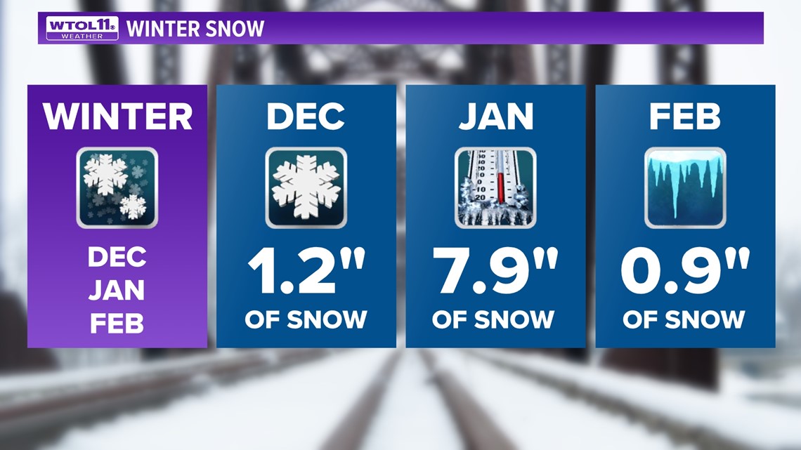
After a bitterly cold end to the calendar year, January flipped the script. The month of January ended a whopping 7.6 degrees warmer than average.
Even with the warm weather pattern, January delivered our biggest snowfall of the season. 4.7 inches of snow accumulated on Jan. 25, contributing to a monthly total of 7.9 inches. This snowfall number still pales in comparison to a normal January. January normally doses out over a foot of accumulation.
Falling just shy of January, February normally features 10.2 inches of accumulation, coming in as our second-snowiest month of the year. This February, far from normal, looked and felt nothing like winter. With just 0.9 inches of snow accumulation and temperatures 6.2 degrees above-average, February brought spring-like temperatures and more rain than snow.
With February in recent memory, let's break down some of last month's weather extremes. With more rain than snow and 4.93 inches of liquid rainfall, February will go down as the fifth-wettest on record. Not surprisingly, February will go down in the history books as one of the least snowy on record.
With paltry snow accumulations of 0.9 inches, February is tied for fourth-least snowy on record. Atop the list are 1987 and 1899, which share the title of least snowy, each of which with a mere half-inch of snowfall.
This February was the polar opposite of the past two years, each of which featured a major snowstorm with snowfall totals over a foot. February 2021 dosed out 22.7 inches of snowfall, making it the seventh-snowiest on record.
Falling shortly behind as the 11th-snowiest in Toledo history, February 2022 brought 19.1 inches of accumulation. After two consecutive snowy Februarys, we went from one extreme to the other this year.
Even though all three occurred during La Niña winters, the differing monthly weather patterns impacted the overall snowfall totals.
So how did climate change impact this winter's weather? Even though weather patterns like the jet stream shape the day-to-day fluctuations in the weather, climate change is responsible for the broader shift in winter weather that's occurred over the past decades.
In the past 10 years alone, winter has grown 2-3 degrees milder, largely due to climate change. This warmer trend has been most noticeable during the month of December, which is 3 degrees warmer than it was a decade ago. The latest data from the National Oceanic and Atmospheric Association, released every decade with new meteorological normals, reflects the overall shift toward milder winter weather due to climate change.
This winter represents the fingerprint of climate change, exemplifying this broader trend. The winter of 2022-2023 will go down as an incredibly mild one with temperatures 5 degrees above average.
Winters like this one are responsible for the shifting climate that has given us a new normal for what to expect with the weather. Mild winters will grow more common and even warmer in the future. This warming trend has shifted precipitation type, creating an atmosphere more conducive to liquid rainfall than frozen snowfall.
While cold and snowy months and winters will still occur in the future, this overall trend due to climate change will grow more pronounced in future decades.
With meteorological winter in the rearview mirror, it's time to look ahead to the spring season. After an incredibly mild start to month, colder conditions will arrive this weekend, sticking around for the next week or two.
The WTOL 11 weather team is forecasting a colder than normal first half of March with temperatures largely in the 30s. What goes up must come down, and after an incredibly warm winter season, we are due for some cooler conditions.
RELATED VIDEO