
TOLEDO, Ohio — This week kicked off the summer season with Memorial Day and a hot start to June.
Now that May is behind us, what can we expect for the start of summer? And how is climate change impacting summer heat? We'll answer those questions and more in this week's edition of Climate Friday.
After a warm Memorial Day weekend, Tuesday delivered our first 90-degree temperature of the year. Temperatures then soared to the 90s on Thursday to kick off the month of June.
The 90-degree warmth is expected to continue into the start of the weekend. So far this year, Toledo has logged a pair of 90-degree days, but that number will likely jump to four by the end of the weekend.
In a typical year, Toledo records 19 days at 90 or warmer. Last year delivered hotter than normal conditions with 23 days in the 90s.
The record? 1988, which saw a whopping 44 days at or above the 90-degree threshold.
Though summer heat has always occurred, climate change is making warm weather more common and intense. Days in the 90s have grown much more common on average. The graph below compares the frequency of 90-degree days between 1970 and 2021.

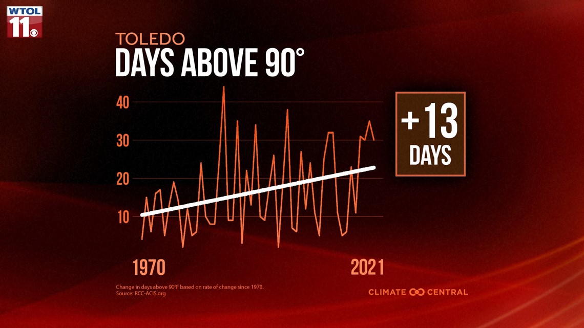
Even though the jet stream contributes to annual variability, the overall trend line is heading up. In the last half century, the average number of yearly 90-degree days has increased by a sizeable 13 days. 90-degree heat is becoming more commonplace due to climate change.
The new normal of climate change has sent temperatures skyrocketing. The latest set of meteorological normals issued by the National Oceanic and Atmospheric Association reflects a significant 2-degree increase in summertime temperatures over the past decade alone.
The new normal in the middle of July is now 87, meaning a 90-degree day is only a few degrees above-average. Climate change is making summer heat more intense and frequent - a trend that will likely continue in the future.
With the heat often comes drought, a phenomenon that has already impacted area farmers this year. Now that May is in the rearview mirror, let's recap the historic rainfall deficit.

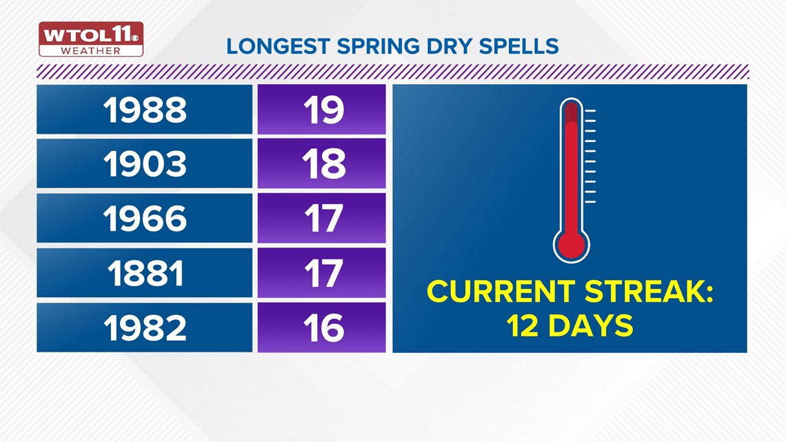
This May will go down in the record books at the sixth-driest on record with only 0.90 inches of rainfall. May is typically the wettest month of the year, bringing 3.82 inches.
This May kicked off a prolonged stretch of dry weather that's still continuing as you read this. Thursday extended our stretch of rain-free weather to 12 days, and Friday will add to the tally.
Saturday will bring the slim hope for a brief pop-up thundershower as a weak cold front moves in from the north. Don't hold your breath though, as rainfall will be sparse.
The WTOL 11 weather team is monitoring potential drought conditions. The official U.S. Drought Monitor has labelled the entire region of northwest Ohio and southeast Michigan as "abnormally dry," a precursor to more severe drought conditions.
Without any meaningful rainfall in the 10-day forecast, drought conditions may develop across the area. By mid-June, this abnormally dry weather pattern may finally snap with more moisture and humidity to provide needed rainfall for farmers and gardeners.
Stay tuned to the WTOL 11 weather team for the latest 10-day forecast.
Climate change is making summertime heat and drought more common and intense, a phenomenon that you've likely noticed over the past few weeks. The warm and dry stretch of weather will continue into early June, but changes are possible by the middle of the month.
RELATED VIDEO